Not any single building can be constructed perfectly, however you want it to be, if there is a single error occurrence on the construction site. It is being said that “nothing is perfect”, but technically, now anything can be perfect, even your construction project.
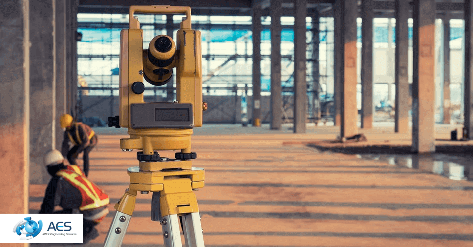
Previously, that was based on rough guesses or inappropriate measurements; now it is exchanged with advanced laser scanning. The answer to the question of how laser scanning makes your construction project accurate is as follows:
- Through the usage of advanced tools like sonar, GPS, and laser scanners.
- You get to know about the location and geographical aspects of the area through spatial data.
- The 3D digital representation of your project will be in front of your eyes, so you can always compare your ongoing construction with it and reduce the chances of errors.
- Through Leica TruView, not only you but all the constructors, engineers, and architects involved can view and add markup.
“Accuracy + Save Time + No delays = Laser Scanning”
It means that before piling up cement, constructors know about Earth’s surface in detail, and 3D models will help them to construct accurately, as a future building is present before their eyes. Not only in construction, but in renovation or remodelling, this laser scanning is bringing transformation.
So, this blog will guide you on the advantages and importance of laser scanning in construction projects.
Recognising the Power of Laser Scanning in Construction
How Sonar and GPS Systems Add Precision
Apex Engineering Services uses more than just laser technology. However, their accuracy is further strengthened by their usage of GPS and sonar equipment. Through sonar (sound navigation and range), engineers can determine distance and depth, which is crucial to identifying subsurface or water-based environments.
In contrast, GPS gives precise geographic coordinates. When combined, these techniques guarantee that each scanned point corresponds to its actual position.
The engineers of AES can quickly align structural pieces, confirm measurements, and maintain consistency across vast or complicated sites with the help of sonar that provides underground information and through GPS's precise location data.
3D Digital Representation: A Clear Picture Before Construction Begins
Normally, the changes happen in any phase of construction. Usually, the main reason behind this is improper information regarding the site or a sudden alteration in the design. This issue is resolved by laser scanning in the UK, which produces 3D digital images of the building or site prior to construction starting.
These models are produced by Apex Engineering Services by combining information gathered from GPS locations, sonar measurements, and high-speed laser scanners.
How Engineers Create 3D Models and What Makes Them Different From 2D?
After collecting precise data, engineers design a 3D model through CAD software. That will represent how your desired project will look in real life.
On the other hand, 2D is flat compared to the 3D model. But through a 3D model, you can view your building from all angles and sizes.
However, what would happen if the design had to be altered while work was underway?
Updates can be made directly in the 3D model by using laser scanning technology. To make sure that any changes remain in line with the actual structure, the updated data can be rescanned, reprocessed, and reloaded into the software. So, this adaptability maintains the project's accuracy even when modifications are made in the middle.
Combining 3D Models with Point Clouds for Greater Accuracy
Combining 3D point clouds with 3D models is where Apex Engineering Services' process truly shines. The gap between design and reality is closed by this integration. The 3D model depicts the intended design, and the 3D point cloud offers an accurate digital record of the location.
Engineers can quickly see the differences between design and reality by placing the model over the scanned data. Any misalignment, improper installation, or structural conflict is immediately apparent. So, 3D Laser Scanning enables adjustments prior to the start of actual work.
If you want to know how 3D laser scanning is playing its role in retrofitting projects, then give a read to this blog.
Leica TruView: Simplifying Complex Data
After gathering complex data, how will you comprehend it? Leica TruView Enterprise can help with it. Apex Engineering Services makes laser scan data available to all the people who are involved in construction through this advanced cloud-based platform.
Project managers, architects, and clients can view, annotate, and share 3D scan data from any browser with Leica TruView. Technical know-how or specialist software is not required. Therefore, better cooperation, quicker decision-making, and smooth communication are all made possible by this user-friendly design.
Errors drastically decrease when everyone is able to visualise the same model and spot problems early. So, it has been confirmed that Leica TruView transforms complicated laser data into understandable, useful insights, bridging the gap between technology and human collaboration.
Real-World Applications of Laser Scanning in the UK
Apex Engineering Services uses 3D laser scanning in a number of different sectors.
- In engineering and construction, it highlights errors and guarantees layout accuracy.
- It helps in the preservation of historic structures in heritage and restoration.
- It enables accurate design integration in architecture.
So, laser scanning guarantees accurate mapping of underground and surface networks, even in infrastructure.
Laser Scanning Process – Apex Engineering Services
- Site Preparation
(Survey Planning & GPS)
- Data Capture
(Laser Scanners collect millions of 3D points)
- Point Cloud Creation
(All scan data combined into a 3D point cloud)
- Data Processing
(Noise removal, alignment & model preparation)
- 3D Model Generation
(Convert point cloud into usable 3D digital model)
- Integration & Analysis
(Combine the model with CAD)
- Collaboration & Sharing
Leica TruView allows team access & annotation)
- Construction Execution
(Use data to guide design & ensure precision)
What are the questions that people have for Apex Engineering Services?
How does laser scanning make construction projects more accurate?
Laser scanning captures millions of precise measurements of a site in seconds. These measurements form a detailed 3D model that shows exact dimensions, angles, and positions. Engineers and architects can then use this data to design and build with confidence, reducing human error and ensuring that what’s built matches the original plan perfectly.
Can laser scanning detect errors before construction begins?
Yes, that’s one of its biggest advantages. Laser scanning provides a complete 3D digital view of the project area before work starts. This helps identify design clashes, uneven surfaces, or incorrect alignments early. Detecting these issues before construction saves time, money, and materials that would otherwise be wasted on rework.
What is a 3D point cloud, and how does it help with accuracy?
A 3D point cloud is a set of millions of tiny data points collected by the scanner. Each point represents a real position on a surface or structure. When these points combine, they create a digital replica of the site. This accurate model helps teams measure, analyse, and plan every stage of construction without repeated site visits.
How do sonar and GPS support laser scanning accuracy?
Sonar and GPS enhance the precision of laser scanning. GPS provides exact location data, ensuring every scan aligns with real-world coordinates. Sonar, on the other hand, measures depth and distance in areas where light-based scanning may not reach, such as tunnels or underwater sites. Together, they help create a complete and highly accurate survey of the environment.
What role does Leica TruView play in improving construction accuracy?
Leica TruView makes laser scan data easy to access and understand. It allows project teams to view, measure, and comment on 3D scans through a web browser. This means everyone, from architects to clients, can collaborate on the same data without needing special software. It reduces miscommunication and ensures everyone works with the same accurate information.
Conclusion
Through laser scanning, Apex Engineering Services is revolutionising the way that construction accuracy is attained. Sonar, GPS, 3D point clouds, CAD formats, and Leica TruView are all combined to remove the mark of doubt. Their method produces true-to-design outcomes, increases productivity, and gets rid of mistakes.
Precision is crucial in the cutthroat construction industry of today. With the use of laser scanning in the UK, AES guarantees that every project is built on a foundation of exactness. So, reach out to their team to start and end your project free of error.